- Jan 13, 2025
- 5 min read
Updated: Apr 15, 2025
As access to data collection becomes easier, the sheer volume of geospatial data being collected is skyrocketing, creating new challenges around storage and processing. Storing and analysing large, complex data on local hardware can be costly and inefficient. This is where cloud-based GIS tools come in, providing scalable storage and high-performance resources that allow users to more effectively handle large amounts of data.

With the rise of cloud computing, GIS tools have become more accessible, flexible and powerful, offering features such as real-time data sharing, team collaboration and reduced infrastructure costs. Cloud-based GIS platforms allow professionals to work with large amounts of data, providing versatility for projects of all sizes. In this article, we'll look at five of the best cloud-based GIS tools.
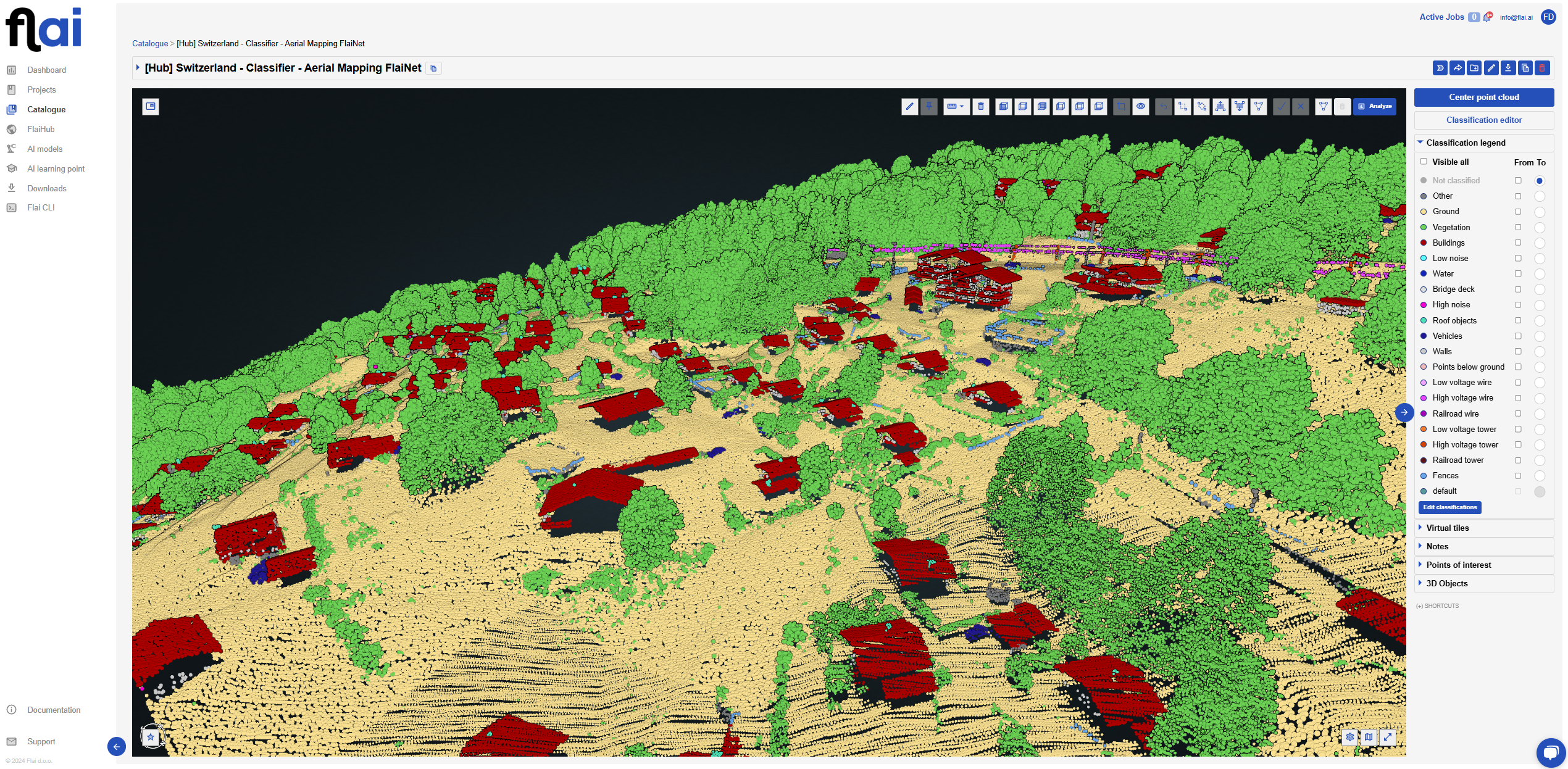
Flai
Flai is a cloud-based, AI-powered platform designed specifically for point cloud classification. Point clouds, which are dense sets of spatial data points, often require accurate classification to be useful for analysis and decision-making.
Try Flai
Benefits
AI-Powered Point Cloud Classification
Flai automates the time-consuming task of classifying point cloud data, which can be labour-intensive and prone to human error. By using AI to perform the classification, it saves significant time and ensures consistent results, making it ideal for handling large volumes of data.
Enhanced Accuracy
Flai's AI algorithms are designed to increase the accuracy of data classification, identifying subtle patterns and distinctions that manual processes or basic algorithms may miss. This accuracy is essential for industries where small errors in spatial data classification can lead to costly mistakes or inefficiencies.
Scalability
As a web-based application, it is designed to handle large datasets without the need for on-premises infrastructure. Its cloud-native design allows it to scale efficiently, making it an excellent choice for large or distributed projects where consultants need to quickly process and classify large amounts of point cloud data.
Affordable price
Flai offers flexible pricing to suit your needs. You can pay only for the resources you use, making it a cost-effective solution for any project size. Alternatively, you can opt for one of Flai’s licenses for more comprehensive access, ensuring a plan that works best for your workflow and budget.
Downside
Exporting is paying
Flai allows you to process and visualize datasets within its platform, but exporting the data for use in other applications requires a payment.
ArcGIS
ArcGIS Online by Esri is one of the most robust and widely used cloud-based GIS platforms available today. Known for its versatility, it appeals to beginners and experts alike, offering everything from basic mapping tools to advanced spatial analysis capabilities.
Benefits
Data Accessibility and Real-Time Collaboration
ArcGIS Online makes it easy to share maps and datasets with team members in real-time, streamlining project workflows.
Seamless Integration with ArcGIS Ecosystem
If you already use Esri tools like ArcGIS Pro, ArcGIS Online is an easy fit, allowing you to transfer data and analyses between platforms without hassle.
Comprehensive Analysis Tools
ArcGIS Online comes with a rich library of tools for spatial analysis—ranging from proximity and hot spot analysis to data enrichment, making it ideal for in-depth geographic investigations.
Downsides
High Subscription Cost
For small teams or independent consultants, the subscription fees can add up, especially for advanced analysis and storage needs.
Steeper Learning Curve for Beginners
The sheer number of options and tools can be overwhelming without training, especially for those new to GIS.
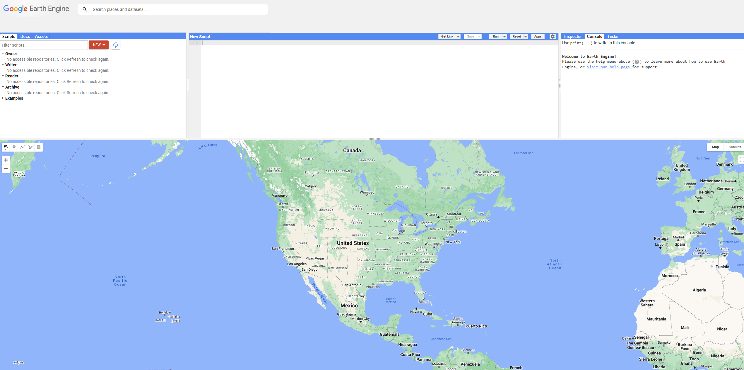
Google Earth Engine
Google Earth Engine is a powerhouse for those working with planetary-scale geospatial data, especially in the environmental sciences. It's loaded with massive public datasets and has unmatched processing power, making it ideal for large-scale environmental projects.
Benefits
Access to a Vast Data Catalog: Google Earth Engine comes preloaded with public datasets, such as Landsat and MODIS, enabling quick access to satellite imagery and earth observation data.
High Processing Power: The cloud infrastructure can handle massive datasets quickly, saving time on data processing—essential for projects requiring high-resolution temporal and spatial data.
Free for Research and Education: For academic, nonprofit, and research use, Google Earth Engine is available at no cost, making it accessible to a wide range of users.
Downsides
Licensing Cost for Commercial Use: Consultants who need the tool for commercial purposes must purchase a license, which can be cost-prohibitive for small businesses.
Requires Programming Skills: Users need a working knowledge of JavaScript or Python to unlock the full potential of the platform, making it less beginner-friendly.
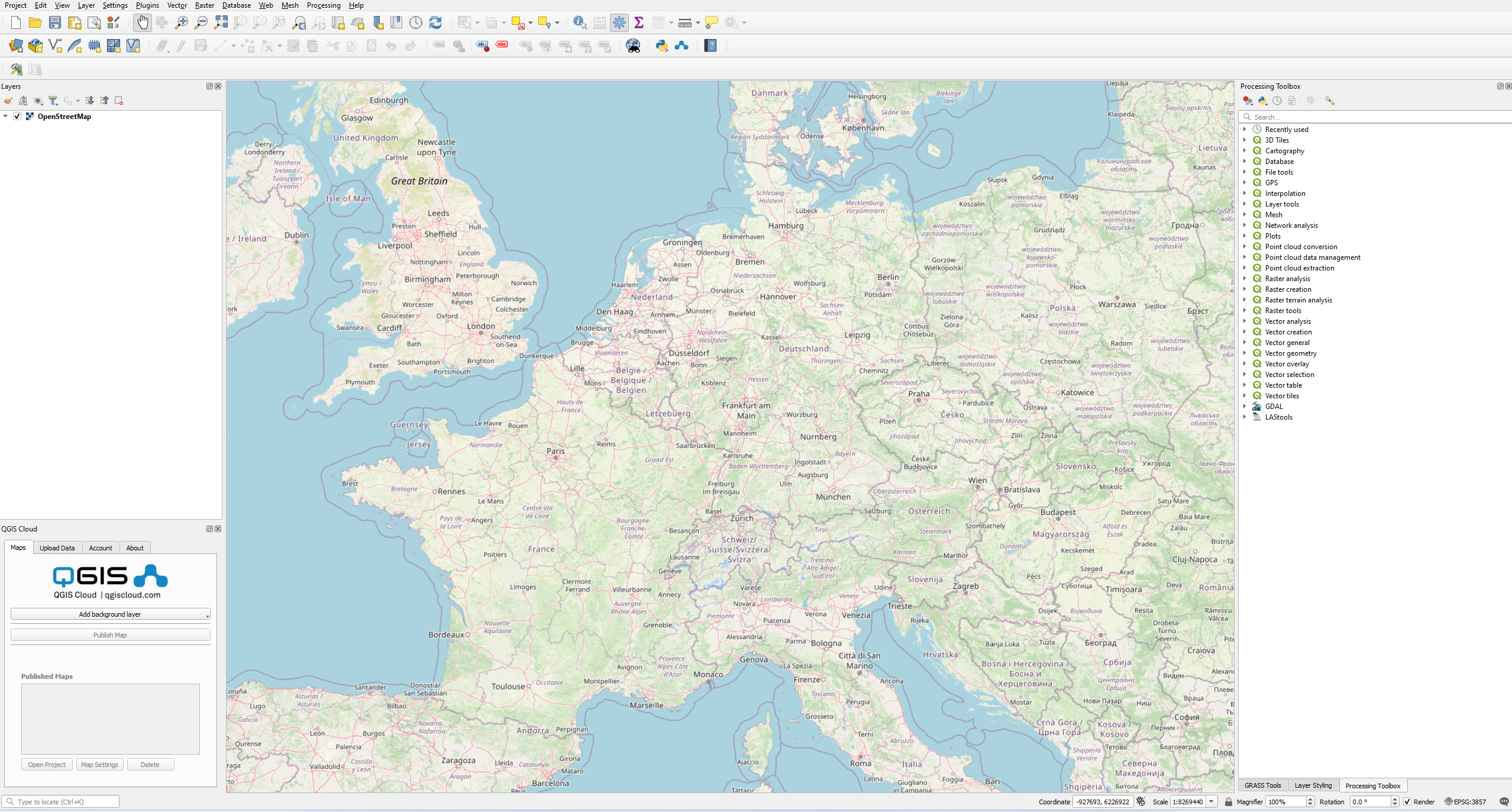
QGIS Cloud
QGIS Cloud is an extension to QGIS, a popular open source desktop GIS platform. It allows users to quickly and easily publish maps online directly from the QGIS desktop environment, making it a great choice for those already familiar with QGIS.
Benefits
Open-Source and Cost-Effective: Based on QGIS, this tool is budget-friendly and appeals to consultants and teams looking for an affordable, open-source GIS solution.
User-Friendly Map Publishing: QGIS Cloud simplifies the process of publishing maps, allowing users to make their data publicly available with just a few clicks.
Customizable with Plugins: QGIS Cloud supports plugins, providing added flexibility for users who want custom configurations or specific functionalities.
Downsides
Fewer Analysis Tools: QGIS Cloud doesn’t offer the same analysis depth as ArcGIS Online, limiting it mostly to visualization rather than intensive data analysis.
Server Dependency: Users need a dedicated server to host larger datasets effectively, which could slow performance if not optimized.
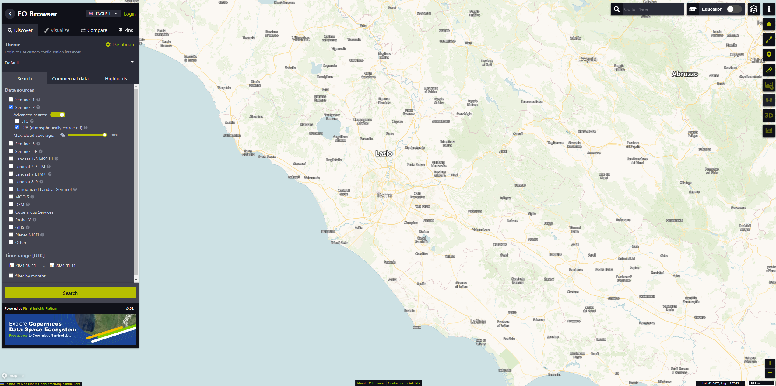
Sentinel Hub
Sentinel Hub is a cloud-based platform for accessing and processing satellite imagery, primarily from the European Space Agency's Sentinel satellites. It’s widely used for environmental monitoring, agriculture, forestry, and land use analysis, offering easy access to high-quality Earth observation data.
Benefits
Extensive Satellite Imagery Access: Sentinel Hub provides quick access to a range of satellite data, including imagery from Sentinel-1, Sentinel-2, and Landsat, allowing consultants to work with up-to-date and historical data.
Flexible and Scalable Processing: The platform allows for on-the-fly processing, enabling users to define custom visualizations, analyze data, and download images without needing to store massive files locally.
API and Integration Options: Sentinel Hub is developer-friendly, with APIs that allow seamless integration into other applications, making it ideal for building custom GIS solutions and workflows.
Downsides
Limited Offline Access: Since Sentinel Hub is a cloud-based service, users need a stable internet connection to access and process satellite data, which may be a limitation in remote areas.
Subscription Costs for Advanced Features: While the platform offers a free tier, access to high-resolution data, additional processing power, and premium services requires a subscription, which may be costly for smaller teams or projects.
Cloud-based GIS tools provide scalable storage, real-time collaboration, and high-performance processing, making them invaluable for managing complex projects. Among these tools, Flai stands out due to its advanced AI-powered capabilities that go beyond standard features. Unlike other tools on the market, Flai automates the labor-intensive task of point cloud classification with unmatched precision, reducing human error and saving significant time. Its flexible, cloud-native architecture can handle large datasets without requiring expensive on-premises infrastructure, making it both cost-effective and scalable for large teams or distributed projects.
Try Flai
Recent Posts
How to Keep Original (Ground) Labels Unchanged When Using Flai Classification
Pushing the Boundaries of Situational Awareness at REPMUS 2025: Our AI-Driven REA Journey