- Aug 5, 2025
- 3 min read
Updated: Aug 6, 2025
Urban trees are vital to the health and sustainability of city environments. They provide a range of ecosystem services, such as cooling urban areas, filtering air pollutants, storing carbon, reducing noise, and supporting biodiversity. As cities expand and face increasing environmental pressures, reliable data on urban greenery becomes essential for effective planning and climate mitigation.
This study was carried out as part of a thesis project and investigates the potential of combining publically available airborne LiDAR data with traditional field measurements to estimate above-ground biomass of trees along Linhartova Street in Ljubljana. With the growing interest in automation and remote sensing, the aim of this blog post is to extract and assess Flai’s tree detection and biomass estimation capabilities compare to manual field-based approaches, focusing on their accuracy, practicality, and potential for large-scale urban applications.
Try Flai
Area of study and Methods
The study focused on Linhartova Street in Ljubljana, Slovenia—a 700-meter-long urban corridor scheduled for major reconstruction. This area was selected to evaluate the impact of urban development on tree biomass and to compare traditional field-based methods with modern remote sensing approaches.
Two types of data were used:
Field measurements: Manual surveys of 142 trees were conducted, recording diameter at breast height (DBH), total tree height, and species.
Airborne Laser Scanning (ALS) : ALS data covering the study area was captured in spring 2022, with a point cloud density of 14.3 points/m². The dataset, provided by the City of Ljubljana, was processed using the Flai web platform, which leverages the Forestry FlaiNet algorithm to automatically detect tree locations, crowns, and heights from the LiDAR point cloud.
The processing was done using openly available LiDAR data, part of the nationwide coverage of Slovenia. On hub.flai.ai, you can access datasets from Slovenia, Finland, Estonia, Poland, Denmark, Spain, Portugal, France, Belgium, the Netherlands, the United Kingdom, and the United States.
Get open LiDAR data
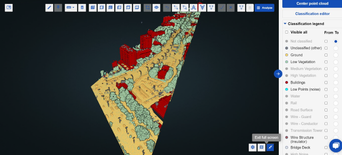
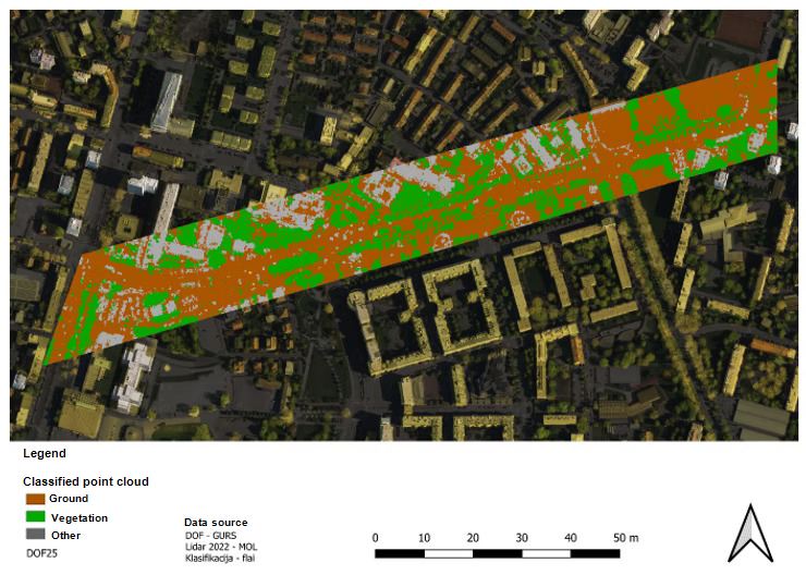
Illustration of a point cloud on Linhartova street on the FlaiNet web platform.
What Is FLAI (Forestry FlaiNet)?
The Forestry FlaiNet algorithm automatically classifies point cloud data into ground, tree trunks, fallen trees, and canopy classes. It also detects individual tree crowns, estimates their height, and determines key trunk parameters such as diameter at breast height (DBH) and location—all without setting foot in the forest or city park. It's a practical tool for cities and researchers who need fast, scalable, and cost-effective insights into urban tree cover.
Try Forestry FlaiNet
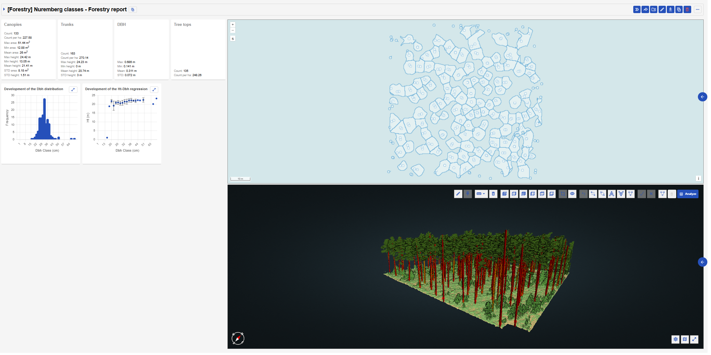
Forestry report created with Forestry FlaiNet: Canopy map, Tree trunk vectors, data graphs, and statistics (DBH, Trunks, Tree tops ...). A demo area is shown that does not correspond to the research area.
Results
The comparison between traditional field measurements and the automated ALS-based tree detection using the Flai Forestry FlaiNet algorithm showed a high level of agreement, demonstrating the potential of LiDAR technology for accurate urban tree monitoring. In total, 142 trees were manually identified and measured on-site, while 156 tree crowns were detected in the ALS point cloud using Flai.
Tree Detection Accuracy
FLAI detected more trees than were actually present — a commission error of 10.1%. This is because it is difficult to determine the number of leaves solely from the crown, especially when the trees are sparse.
It also missed 3.8% of real trees — the omission error — especially smaller or overshadowed trees.
Tree Height Accuracy
FLAI underestimated tree heights by an average of 1.1 meter.
The discrepancy may stem from ALS resolution and the nature of point cloud sampling, which sometimes misses the exact tree top.
Field measurements used a Haglöf Vertex IV laser instrument, producing more accurate height data under controlled observation.
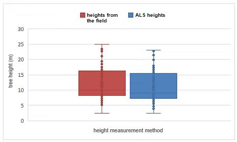
Comparison of tree heights measured with Vertex in the field (red) and obtained from ALS (blue).
Final thoughts
This thesis project underscores the strong potential of combining remote sensing technology, particularly Airborne Laser Scanning (ALS), with traditional field-based measurements to assess and monitor urban trees. Using Linhartova Street in Ljubljana as a real-world test site, the study demonstrates how platforms like Flai’s Forestry FlaiNet can bring automation, scalability, and efficiency to what has historically been a time-consuming and manual process.
ALS offers a fast, scalable, and cost-effective way to detect tree crowns, estimate heights, and assess canopy structure. When paired with the FlaiNet algorithm, which automatically identifies individual trees and extracts trunk parameters, the results showed strong alignment with field data—exhibiting only minor commission and omission errors.
In urban environments undergoing transformation—like Linhartova Street—such tools provide valuable insights into above-ground biomass, urban greenery, and ecosystem services. By enabling cities to monitor tree cover remotely, they support data-driven planning, climate resilience, and more effective green infrastructure management—all without setting foot in the field.
Try Flai
**The entire blog post was written based on Kristina Kleva's thesis, supervised by doc. dr. Mitja Skudnik.
Kleva K. Ocena sprememb nadzemne biomase dreves po rekonstrukciji Linhartove ulice v Ljubljani s terensko izmero ter zračnim laserskim skeniranjem (LiDAR). Dipl. delo (UN). Ljubljana, Univ. v Ljubljani, Biotehniška fakulteta Oddelek za gozdarstvo in obnovljive gozdne vire, 2025
Tags:
Recent Posts
How to Keep Original (Ground) Labels Unchanged When Using Flai Classification
Pushing the Boundaries of Situational Awareness at REPMUS 2025: Our AI-Driven REA Journey