- Dec 20, 2024
- 4 min read
LiDAR technology has transformed the way we map terrain and collect spatial data, becoming more accessible as hardware advances and costs fall. However, despite its growing availability, the processing of raw LiDAR data remains challenging, especially when handled manually. Manual data processing is time-consuming, error-prone and requires specialised skills, especially as datasets increase in complexity and volume. These challenges highlight the need for automated solutions. The emergence of AI-powered tools is reshaping the landscape by enabling efficient, high-quality data processing for applications across multiple sectors.
Try Flai web application
Challenges of Manual Processing
LiDAR technology has revolutionised terrain mapping and is now increasingly used for data acquisition due to rapid advances in hardware and significant cost reductions. Although LiDAR data has become more accessible, the processing of raw data is still a major challenge.
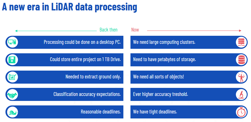
In contrast to traditional imaging data, LiDAR captures large amounts of data, which means that the exact spatial location of each laser point needs to be stored alongside additional attributes. This leads to large file sizes and complex datasets. The manual processing of these datasets is not only labour intensive, but also prone to human error which can cause data inconsistencies. In addition, extracting meaningful information from seemingly random point clouds requires specialised skills and complex algorithms. As the demand for LiDAR data grows, so does the need for more efficient and automated tools to handle these challenges.
The automation of LiDAR data processing is enhanced by advanced AI that optimises each step for speed, accuracy and cost-efficiency. These tools handle bulk data import, metadata generation and noise removal, ensuring high data quality from the start. Automated systems quickly handle data cleaning, point cloud classification and feature extraction, enabling teams to meet project deadlines faster.
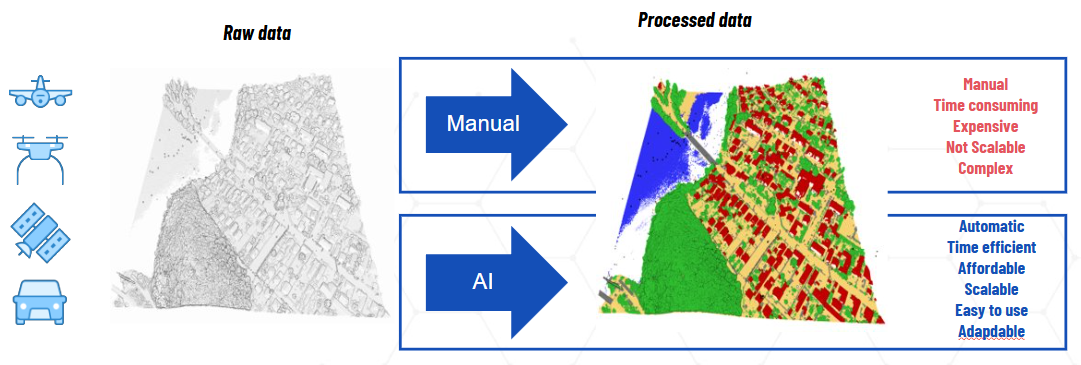
By applying consistent algorithms to classify and filter data, automation minimises human error, resulting in higher accuracy and more reliable data quality. This consistency reduces the need for costly rework as output is consistent and meets pre-defined standards. For example, in a project involving the extraction of ground points from a densely vegetated rockface, AI algorithms processed a high-density LiDAR point cloud to accurately represent the complex morphology of the terrain, significantly reducing the time and effort compared to manual methods.
The Role of AI in Point Cloud Data Classification
Flai is a prominent tool in AI-powered point cloud classification, automating complex data processing tasks with high accuracy. Used in real-world projects, Flai’s technology can quickly identify features like ground points in LiDAR data, even in challenging terrains. Beyond classification, it supports advanced queries and produces outputs like vectorization, rasterization, and biomass analysis, enhancing data utility across applications. By automating these processes, it streamlines workflows, reduces manual labor, and improves data quality, benefiting infrastructure planning, environmental monitoring, and urban development. This automation accelerates project timelines and ensures reliable data for better decision-making in diverse fields.
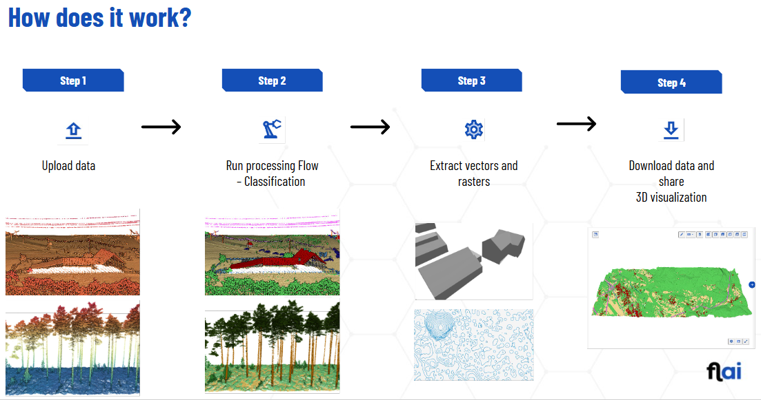
Processing a point cloud in the Flai web app consists of four key steps:
Upload Data: Begin by uploading geospatial or point cloud data into the system.
Run Processing Flow – Classification: The platform processes the uploaded data, classifying elements like terrain, vegetation, and structures.
Extract Vectors and Rasters: The processed data is transformed into vector and raster formats for deeper analysis or visualization.
Download and Share 3D Visualization: Finally, download the results and access an interactive 3D visualization for sharing or further use.
Try Flai
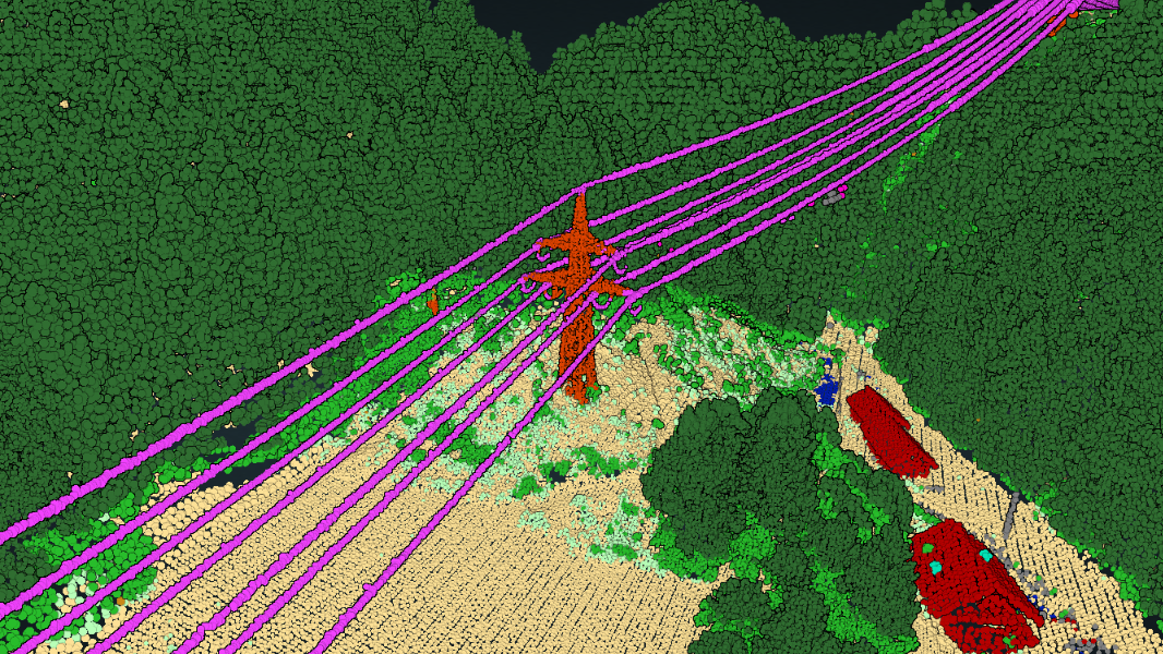
Flai's AI-powered point cloud classification technology is instrumental in enhancing workflows and data quality across various sectors. In the energy industry, Flai collaborated with ELES, Slovenia's electricity transmission system operator, to monitor vegetation growth near power lines. By processing LiDAR data, Flai's AI models accurately identified vegetation encroaching on transmission corridors, enabling ELES to prioritize maintenance and mitigate risks of outages and fires.
To dive deeper into how Flai's AI models supported ELES in monitoring vegetation near power lines and mitigating risks, explore their detailed blog post here.
In forestry, Flai partnered with Umweltdata GmbH to automate forest inventory processes. Utilizing high-density LiDAR point clouds, Flai's AI algorithms classified ground points and tree structures, facilitating precise assessments of forest biomass and health.
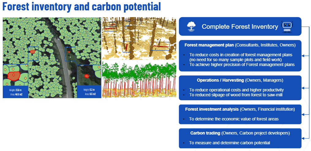
To learn more about how Flai’s AI-powered solutions transformed forest inventory for Umweltdata GmbH, read their full blog post here.
Future Prospects of AI in LiDAR
The future of AI in LiDAR processing is poised for major advancements, with AI enabling real-time data interpretation and rapid insights across applications like autonomous driving, emergency response, and environmental monitoring. Enhanced algorithms may also allow AI to recognize finer details in complex terrains, supporting more precise mapping and adaptable LiDAR applications in diverse environments without manual recalibration.
AI’s integration with 3D modeling and virtual reality could make LiDAR data more accessible for planning and simulation. Additionally, the growth of Explainable AI (XAI) will improve understanding and trust in these systems, especially in critical fields. As point cloud datasets expand, AI-driven LiDAR is set to become even more effective and versatile across industries.
Try Flai web application
AI-driven automation in LiDAR data processing is paving the way for faster, more accurate and cost-effective workflows. By eliminating manual errors and improving data reliability, tools like Flai are supporting critical projects and driving advances in infrastructure, environmental protection, and urban development. As AI technology continues to evolve, the future of LiDAR processing holds great promise with real-time data interpretation, adaptive algorithms, and integration with 3D and VR applications. These innovations will make LiDAR data even more versatile and valuable, enabling industries to tackle increasingly complex challenges with confidence and precision.
Recent Posts
How to Keep Original (Ground) Labels Unchanged When Using Flai Classification
Pushing the Boundaries of Situational Awareness at REPMUS 2025: Our AI-Driven REA Journey